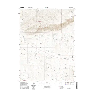
2017 Map of Cliff Ridge
USGS Topo · Published 2017About this map
Cliff Ridge dominates this northern Uintah County landscape, forming a massive east-west topographic spine that overlooks a complex system of arid drainages. The area is defined by its deep draws and ridges, including Bourdette Draw and Blind Draw, which feed into larger systems like Cliff Cr and Cow Wash. In the southern half of the quadrangle, the high ground of The Rim Rock provides a natural vantage over First Gap, marking a distinct shift toward the broad expanse of Deadman Bench. This 2017 survey details the essential water infrastructure of this high desert environment, identifying Cow Wash Reservoir and Davis Spring as key points of interest. Long-established transportation routes such as Old Bonanza Hwy and Deadman Bench Rd provide access through the complex terrain of Squaw Ridge and Raven Ridge, where the geological formations of Snake John Reef create a prominent landscape barrier.
Find a feature on this map
31 named features on this map. Tap any name to fly to it.
Don’t see what you’re looking for? This feature index may not catch every label — zoom into the map to look around manually.
Map Details
Editions of this 2017 Cliff Ridge Map
This is the sole edition of this map. No revisions or reprints were ever made.
Other maps of this area

1885 · Ashley
USGS Topo · 1:250,000

1907 · Jensen
USGS Topo · 1:125,000

1910 · Jensen
USGS Topo · 1:125,000

1954 · Vernal
USGS Topo · 1:250,000

1955 · Stuntz Reservoir
USGS Topo · 1:24,000

1955 · Split Mountain
USGS Topo · 1:24,000

1958 · Vernal
USGS Topo · 1:250,000

1960 · Vernal
USGS Topo · 1:250,000
1965 · Dinosaur Quarry
USGS Topo · 1:24,000
1965 · Jensen
USGS Topo · 1:24,000