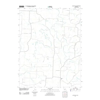
2011 Map of Clifton City
USGS Topo · Published 2011About this map
Clifton City and the surrounding Cooper County countryside are defined by the winding course of the Lamine River, which carves through the landscape alongside numerous tributaries like Muddy Creek and Shaver Creek. This 2011 survey documents a rural Missouri geography characterized by a network of local roads such as Swinging Bridge Rd and Bugger Town Rd, connecting small settlements like Bush and Lookout. For those tracing local heritage, the map identifies several burial grounds, including Saint Josephs Cemetery, Sowers Cemetery, Lamine Cemetery, Irving Cemetery, and Lee Cemetery, providing essential coordinates for genealogical research. The presence of Fortunes Lake and various named branches, such as Pipkin Branch and Johnson Branch, highlights the importance of the local watershed to the region's agricultural and rural layout.
Find a feature on this map
45 named features on this map. Tap any name to fly to it.
Don’t see what you’re looking for? This feature index may not catch every label — zoom into the map to look around manually.
Map Details
Editions of this 2011 Clifton City Map
This is the sole edition of this map. No revisions or reprints were ever made.
Other maps of this area

1887 · Sedalia
USGS Topo · 1:125,000

1888 · Boonville
USGS Topo · 1:125,000

1894 · Sedalia
USGS Topo · 1:125,000

1944 · Sedalia East
USGS Topo · 1:24,000

1946 · Sedalia East
USGS Topo · 1:24,000

1947 · Jefferson City
USGS Topo · 1:250,000

1953 · Pilot Grove North
USGS Topo · 1:24,000

1953 · Pilot Grove South
USGS Topo · 1:24,000
1953 · Otterville East
USGS Topo · 1:24,000
1953 · Nelson
USGS Topo · 1:24,000