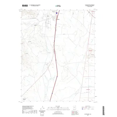
2020 Map of Clifton House
USGS Topo · Published 2020About this map
Raton and the surrounding high plains of Colfax County appear here in a landscape defined by its historic transit corridors and water sources. The Canadian River cuts through the western portion of the area, winding past the Clifton Hills and the site of the Clifton House, a notable stagecoach stop on the Santa Fe Trail. The terrain transitions from the steep drainage of Cottonwood Canyon and the height of Green Mtn to the flatter expanses of the east, where Chicorica Cr and Una de Gato Cr cross the plains. Infrastructure to the south includes Davis Reservoir and the Raton Municipal Airport/Crews Field, while the northern settlement of Dillon sits at the base of the canyonlands. This detail illustrates how modern transportation like Frontage Rd follows the same natural routes that have guided travelers through this pass for generations.
Find a feature on this map
35 named features on this map. Tap any name to fly to it.
Don’t see what you’re looking for? This feature index may not catch every label — zoom into the map to look around manually.
Map Details
Editions of this 2020 Clifton House Map
This is the sole edition of this map. No revisions or reprints were ever made.
Other maps of this area

1912 · Raton
USGS Topo · 1:62,500

1914 · Raton
USGS Topo · 1:62,500

1915 · Brilliant
USGS Topo · 1:62,500

1915 · Koehler
USGS Topo · 1:62,500

1917 · Koehler
USGS Topo · 1:62,500

1954 · Raton
USGS Topo · 1:250,000

1958 · Raton
USGS Topo · 1:250,000

1971 · Clifton House
USGS Topo · 1:24,000
1971 · Raton
USGS Topo · 1:24,000
1971 · Red River Peak
USGS Topo · 1:24,000