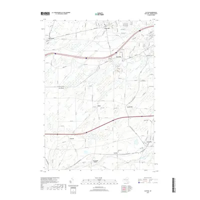
2019 Map of Clifton
USGS Topo · Published 2019About this map
Scottsville anchors the southeast corner of this Monroe County landscape, where Oatka Creek and the West Shore railroad corridor define the local geography. The map reveals a dense network of burial sites that trace the region's genealogical history, from the North Chili Rural Cem in the north to the Garbuttsville Cem and Quaker Cem near the southern boundary. These cemeteries, alongside smaller hamlets like Clifton, Belcoda, and Garbutt, point to a long-established settlement pattern deeply connected to the waterways of Black Creek and Mill Cr. This 2019 survey captures the modern road network, including Buffalo Rd and Chili Ave, while preserving the locations of legacy landmarks such as Munson Hill and the West Shore Ponds, providing a clear view of how these historic communities have integrated into the contemporary suburban and agricultural landscape of Chili and Wheatland.
Find a feature on this map
131 named features on this map. Tap any name to fly to it.
Don’t see what you’re looking for? This feature index may not catch every label — zoom into the map to look around manually.
Map Details
Editions of this 2019 Clifton Map
This is the sole edition of this map. No revisions or reprints were ever made.
Other maps of this area

1895 · Rochester
USGS Topo · 1:62,500

1898 · Rochester
USGS Topo · 1:62,500

1899 · Brockport
USGS Topo · 1:62,500

1901 · Honeoye
USGS Topo · 1:62,500

1904 · Caledonia
USGS Topo · 1:62,500

1904 · Honeoye
USGS Topo · 1:62,500

1912 · Rochester
USGS Topo · 1:62,500

1920 · Rochester
USGS Topo · 1:62,500

1931 · Rochester West
USGS Topo · 1:24,000

1932 · Spencerport
USGS Topo · 1:24,000