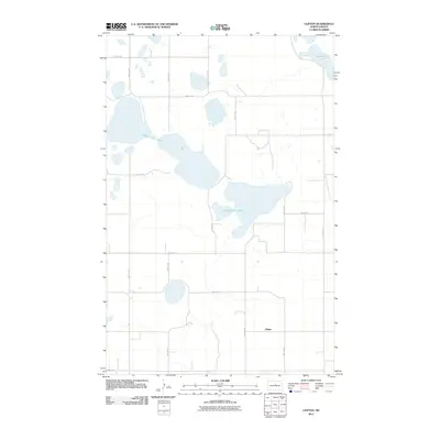
2011 Map of Clifton
USGS Topo · Published 2011About this map
Antelope Lakes dominate the central landscape of this Pierce County region, where the prairie terrain is punctuated by significant water bodies and glacial depressions. The small settlement of Clifton is positioned in the southern portion of the quadrangle, serving as a focal point for the surrounding rural section lines. The hydrography of the area is defined by the North Fork Sheyenne River along the eastern margin and Lesmeister Lake in the northeastern corner. This 2011 survey reflects the enduring grid of the Public Land Survey System, with gravel and dirt roads like 40th St NE and 22nd Ave NE following strictly rectilinear paths through the open country. The distribution of these seasonal lakes and intermittent streams indicates a landscape shaped by drainage patterns common to the North Dakota prairie, where water collection points are vital geographic markers.
Find a feature on this map
17 named features on this map. Tap any name to fly to it.
Don’t see what you’re looking for? This feature index may not catch every label — zoom into the map to look around manually.
Map Details
Editions of this 2011 Clifton Map
This is the sole edition of this map. No revisions or reprints were ever made.
Other maps of this area

1940 · Aylmer
USGS Topo · 1:62,500

1941 · Selz
USGS Topo · 1:62,500
1951 · Harvey
USGS Topo · 1:24,000

1951 · Martin
USGS Topo · 1:24,000

1951 · Anamoose SW
USGS Topo · 1:24,000

1951 · Selz NW
USGS Topo · 1:24,000

1952 · New Rockford
USGS Topo · 1:250,000

1953 · Devils Lake
USGS Topo · 1:250,000

1954 · Minot
USGS Topo · 1:250,000

1954 · McClusky
USGS Topo · 1:250,000