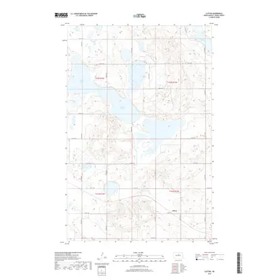
2018 Map of Clifton
USGS Topo · Published 2018About this map
Clifton serves as the namesake hub of this rural Pierce County landscape, situated amidst a complex network of wetlands and seasonal basins. The terrain is defined by the significant presence of Antelope Lakes, which span several sections in the north-central portion of the map, and the smaller Lesmeister Lake tucked into the northeast corner. This geography of the northern prairies is crisscrossed by a rigid grid of section-line roads, including 33rd St NE and 24th Ave NE, which provide access to the dispersed agricultural tracts. The Public Land Survey System (PLSS) boundaries, such as t152n r74w and t152n r73w, reveal the structured division of the territory into townships and ranges, illustrating the systematic settlement patterns of the North Dakota plains.
Find a feature on this map
22 named features on this map. Tap any name to fly to it.
Don’t see what you’re looking for? This feature index may not catch every label — zoom into the map to look around manually.
Map Details
Editions of this 2018 Clifton Map
This is the sole edition of this map. No revisions or reprints were ever made.
Other maps of this area

1940 · Aylmer
USGS Topo · 1:62,500

1941 · Selz
USGS Topo · 1:62,500
1951 · Harvey
USGS Topo · 1:24,000

1951 · Martin
USGS Topo · 1:24,000

1951 · Anamoose SW
USGS Topo · 1:24,000

1951 · Selz NW
USGS Topo · 1:24,000

1952 · New Rockford
USGS Topo · 1:250,000

1953 · Devils Lake
USGS Topo · 1:250,000

1954 · Minot
USGS Topo · 1:250,000

1954 · McClusky
USGS Topo · 1:250,000