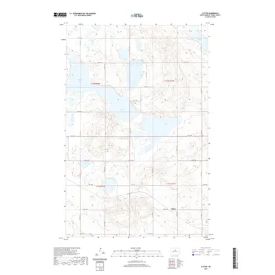
2020 Map of Clifton
USGS Topo · Published 2020About this map
Antelope Lakes dominate the central landscape of this Pierce County region, defining a prairie pothole environment characterized by numerous small, scattered wetlands and larger ephemeral water bodies. The settlement of Clifton is located in the southeastern portion of the map, situated near the intersection of 33rd St NE and 26th Ave NE. This area illustrates the classic North Dakota section-line road grid, with routes like 40th St NE and 22nd Ave NE segmenting the agricultural terrain into precise squares. To the northeast, Lesmeister Lake provides another significant hydrological feature in a territory largely shaped by glacial action. The landscape is primarily rural, with the Public Land Survey System divisions of t152n r74w and t151n r73w providing the underlying organizational structure for the farmsteads and fields that span the quadrangle.
Find a feature on this map
23 named features on this map. Tap any name to fly to it.
Don’t see what you’re looking for? This feature index may not catch every label — zoom into the map to look around manually.
Map Details
Editions of this 2020 Clifton Map
This is the sole edition of this map. No revisions or reprints were ever made.
Other maps of this area

1940 · Aylmer
USGS Topo · 1:62,500

1941 · Selz
USGS Topo · 1:62,500
1951 · Harvey
USGS Topo · 1:24,000

1951 · Martin
USGS Topo · 1:24,000

1951 · Anamoose SW
USGS Topo · 1:24,000

1951 · Selz NW
USGS Topo · 1:24,000

1952 · New Rockford
USGS Topo · 1:250,000

1953 · Devils Lake
USGS Topo · 1:250,000

1954 · Minot
USGS Topo · 1:250,000

1954 · McClusky
USGS Topo · 1:250,000