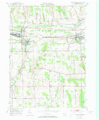
1951 Map of Clifton Springs
USGS Topo · Published 1974About this map
Hill Cumorah stands prominently in the northern landscape of this Ontario County region, overlooking a complex network of waterways and rail lines. The Canandaigua Outlet meanders through the centers of Manchester and Shortsville, providing the historical backbone for local development. Further east, the village of Clifton Springs is anchored by the large Sanitarium and a concentration of civic life along Central Avenue. The era’s reliance on rail transport is evident where the New York Central and Lehigh Valley tracks intersect this terrain, connecting these mill towns to the broader Finger Lakes economy.
Find a feature on this map
73 named features on this map. Tap any name to fly to it.
Don’t see what you’re looking for? This feature index may not catch every label — zoom into the map to look around manually.
Map Details
Editions of this 1951 Clifton Springs Map
3 editions found
Other maps of this area

1899 · Palmyra
USGS Topo · 1:62,500

1900 · Macedon
USGS Topo · 1:62,500

1900 · Canandaigua
USGS Topo · 1:62,500

1902 · Phelps
USGS Topo · 1:62,500

1902 · Palmyra
USGS Topo · 1:62,500

1903 · Canandaigua
USGS Topo · 1:62,500

1942 · Canandaigua
USGS Topo · 1:31,680
1942 · Canandaigua Lake
USGS Topo · 1:31,680

1942 · Rushville
USGS Topo · 1:31,680

1942 · Stanley
USGS Topo · 1:31,680