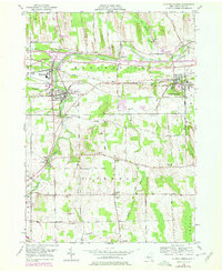
1951 Map of Clifton Springs
USGS Topo · Published 1978About this map
The Canandaigua Outlet carves a path through the heart of the Finger Lakes region in this mid-century survey, defining the industrial and residential corridors of Manchester and Shortsville. The village of Clifton Springs is a primary focal point, notable for the prominent Sanitarium and its proximity to the Conrail lines. This era shows the expansion of transportation infrastructure, with the New York State Thruway cutting through the northern landscape near Manchester Center. Rural life and ancestry are well-documented through a dense concentration of local landmarks, including the County Home and its associated County Home Cem, and numerous schoolhouses such as School No 1 and School No 6. The terrain transitions from the wetland of Bunker Hill Swamp to the distinctive elevations of Cumorah Hill and Bunker Hill, providing a detailed look at the rural landscape before late-20th-century development.
Find a feature on this map
56 named features on this map. Tap any name to fly to it.
Don’t see what you’re looking for? This feature index may not catch every label — zoom into the map to look around manually.
Map Details
Editions of this 1951 Clifton Springs Map
3 editions found
Other maps of this area

1899 · Palmyra
USGS Topo · 1:62,500

1900 · Macedon
USGS Topo · 1:62,500

1900 · Canandaigua
USGS Topo · 1:62,500

1902 · Phelps
USGS Topo · 1:62,500

1902 · Palmyra
USGS Topo · 1:62,500

1903 · Canandaigua
USGS Topo · 1:62,500

1942 · Canandaigua
USGS Topo · 1:31,680
1942 · Canandaigua Lake
USGS Topo · 1:31,680

1942 · Rushville
USGS Topo · 1:31,680

1942 · Stanley
USGS Topo · 1:31,680