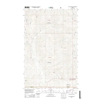
2013 Map of Clifty Mountain
USGS Topo · Published 2013About this map
Clifty Mtn and the surrounding high country of the Selkirk Mountains dominate this high-altitude landscape where the Kanisku National Forest meets the Kootenai National Forest. The map documents a complex drainage system where waters flow from the slopes of Iron Mtn and Buck Mtn into numerous named tributaries including Pulp Cr, Pinochle Cr, and Rummy Cr. A notable geographic transition occurs along the southern boundary where the terrain shifts into Bonner Co near N Callahan Cr. This survey details the remote infrastructure of the early 21st century, showing the winding paths of Black Mtn Rd and Boulder Creek Rd as they navigate the ridges and basins. These routes provide access to isolated landmarks such as Divide Lake and the prominent heights of Bald Eagle Mtn and Star Mtn along the eastern edge of the quadrangle.
Find a feature on this map
39 named features on this map. Tap any name to fly to it.
Don’t see what you’re looking for? This feature index may not catch every label — zoom into the map to look around manually.
Map Details
Editions of this 2013 Clifty Mountain Map
This is the sole edition of this map. No revisions or reprints were ever made.
Other maps of this area

1911 · Priest Lake
USGS Topo · 1:250,000

1913 · Priest Lake
USGS Topo · 1:250,000

1951 · Mt Pend Oreille
USGS Topo · 1:62,500

1951 · Elmira
USGS Topo · 1:62,500

1958 · Sandpoint
USGS Topo · 1:250,000

1963 · Sandpoint
USGS Topo · 1:250,000
1965 · Curley Creek
USGS Topo · 1:24,000
1965 · Leonia
USGS Topo · 1:24,000

1965 · Twentymile Creek
USGS Topo · 1:24,000
1965 · Moyie Springs
USGS Topo · 1:24,000