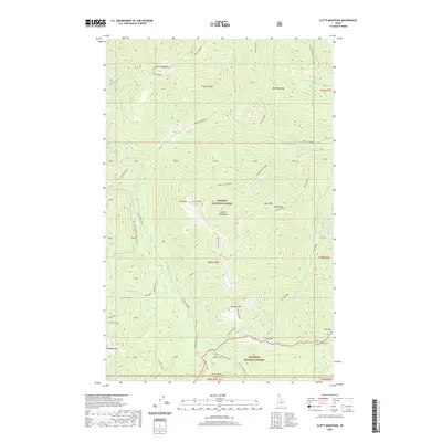
2020 Map of Clifty Mountain
USGS Topo · Published 2020About this map
Clifty Mountain and the surrounding Cabinet Mountains define this high-elevation landscape along the border of Boundary and Bonner counties. The area is dominated by the protected lands of Kaniksu National Forest and Kootenai National Forest, where steep ridges like McGinty Ridge and Slate Ridge drop into drainage basins for Boulder Creek and its many branches. High-altitude features such as Divide Lake and the open stretches of Boulder Meadows provide clear reference points for the remote terrain. Access is marked by a network of forest routes, including Black Mtn Rd and Boulder Creek Rd, which traverse the slopes near Iron Mountain and Clifty Peak. Named local landmarks like Orville Heath and Kelly Pass highlight the specific nomenclature of the Idaho panhandle's interior wilderness.
Find a feature on this map
49 named features on this map. Tap any name to fly to it.
Don’t see what you’re looking for? This feature index may not catch every label — zoom into the map to look around manually.
Map Details
Editions of this 2020 Clifty Mountain Map
This is the sole edition of this map. No revisions or reprints were ever made.
Other maps of this area

1911 · Priest Lake
USGS Topo · 1:250,000

1913 · Priest Lake
USGS Topo · 1:250,000

1951 · Mt Pend Oreille
USGS Topo · 1:62,500

1951 · Elmira
USGS Topo · 1:62,500

1958 · Sandpoint
USGS Topo · 1:250,000

1963 · Sandpoint
USGS Topo · 1:250,000
1965 · Curley Creek
USGS Topo · 1:24,000
1965 · Leonia
USGS Topo · 1:24,000

1965 · Twentymile Creek
USGS Topo · 1:24,000
1965 · Moyie Springs
USGS Topo · 1:24,000