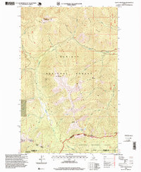
1996 Map of Clifty Mountain
USGS Topo · Published 1999About this map
The Cabinet Mountains define the character of this 1990s forest survey, showcasing the high-elevation terrain where the Kaniksu National Forest and Kootenai National Forest meet. The map reveals a landscape shaped by both natural waterways and resource extraction, notably centered around the Boulder Mine and a nearby Gravel Pit. The rugged topography is etched with numerous drainages, including the prominent Boulder Creek and its several forks, which serve as the primary hydrologic network for the region. Significant peaks like Clifty Mountain and Iron Mountain dominate the skyline, while the Katka Trail provides one of the few established routes through the steep ridges. The inclusion of the Three Rivers Ranger District and Bonners Ferry Ranger District administrative boundaries highlights the active management of these timber and recreational lands near the Boundary Co Bonner Co line.
Find a feature on this map
36 named features on this map. Tap any name to fly to it.
Don’t see what you’re looking for? This feature index may not catch every label — zoom into the map to look around manually.
Map Details
Editions of this 1996 Clifty Mountain Map
This is the sole edition of this map. No revisions or reprints were ever made.
Other maps of this area

1911 · Priest Lake
USGS Topo · 1:250,000

1913 · Priest Lake
USGS Topo · 1:250,000

1951 · Mt Pend Oreille
USGS Topo · 1:62,500

1951 · Elmira
USGS Topo · 1:62,500

1958 · Sandpoint
USGS Topo · 1:250,000

1963 · Sandpoint
USGS Topo · 1:250,000
1965 · Curley Creek
USGS Topo · 1:24,000
1965 · Leonia
USGS Topo · 1:24,000

1965 · Twentymile Creek
USGS Topo · 1:24,000
1965 · Moyie Springs
USGS Topo · 1:24,000