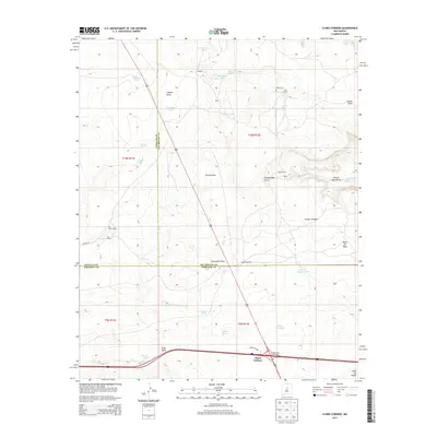
2013 Map of Clines Corners
USGS Topo · Published 2013About this map
Clines Corners marks the busy intersection of major transit routes on this high-plains landscape, where the Clines Corner Interchange facilitates the meeting of east-west and north-south traffic. This area is a tri-county junction, where the boundaries of Santa Fe, San Miguel, and Torrance counties converge. The terrain is defined by a network of drainage draws and livestock tanks, essential infrastructure for the local ranching tradition. Significant family holdings and small settlements are scattered throughout, including Los Norias Ranch, Hagerman Ranch, and Tapia Ranch. Genealogists may find value in the location of the Tapia Cem and named points like Los Cavos. The map also captures several natural basins such as Laguna Blanca and Laguna Colorado, which punctuate the arid landscape below the prominent Mesa las Tapias.
Find a feature on this map
43 named features on this map. Tap any name to fly to it.
Don’t see what you’re looking for? This feature index may not catch every label — zoom into the map to look around manually.
Map Details
Editions of this 2013 Clines Corners Map
This is the sole edition of this map. No revisions or reprints were ever made.
Other maps of this area

1894 · Lamy
USGS Topo · 1:125,000

1954 · Santa Fe
USGS Topo · 1:250,000

1954 · Fort Sumner
USGS Topo · 1:250,000

1958 · Fort Sumner
USGS Topo · 1:250,000

1958 · Santa Fe
USGS Topo · 1:250,000

1960 · Lobo Hill
USGS Topo · 1:62,500

1960 · Stanley
USGS Topo · 1:62,500
1966 · El Cabo
USGS Topo · 1:24,000
1966 · Mesa El Toro
USGS Topo · 1:24,000
1966 · Clines Corners
USGS Topo · 1:24,000