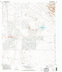
1995 Map of Clint NE
USGS Topo · Published 1995About this map
The eastern edge of the Hueco Mountains gives way to a sprawling arid landscape marked by significant water management and recreation infrastructure in the mid-1990s. This desert floor near El Paso is defined by a distinct grid of development and the presence of specialized local landmarks like Mountain Shadow Lake, which features a Boat Ramp and Athletic Fields. The terrain is punctuated by isolated rises such as Backbone Hill and Horse Hill, providing topographic variation against the broader expanse of Sand Dunes.
Find a feature on this map
17 named features on this map. Tap any name to fly to it.
Don’t see what you’re looking for? This feature index may not catch every label — zoom into the map to look around manually.
Map Details
Editions of this 1995 Clint NE Map
This is the sole edition of this map. No revisions or reprints were ever made.
Other maps of this area

1896 · El Paso
USGS Topo · 1:125,000

1903 · Cerro Alto
USGS Topo · 1:125,000

1908 · El Paso
USGS Topo · 1:125,000

1939 · Heuco Tanks
USGS Topo · 1:62,500

1940 · Heuco Tanks
USGS Topo · 1:62,500

1941 · Clint
USGS Topo · 1:62,500

1941 · Heuco Mountains
USGS Topo · 1:62,500

1942 · Borrego
USGS Topo · 1:62,500

1943 · Heuco Mountains
USGS Topo · 1:62,500

1944 · Heuco Tanks
USGS Topo · 1:62,500