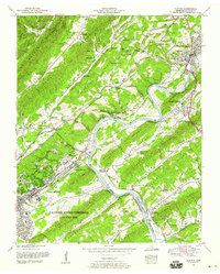
1952 Map of Clinton
USGS Topo · Published 1959About this map
The US Atomic Energy Commission (Oak Ridge Area) dominates the southwestern quadrant of this mid-century map, reflecting the profound transformation of the East Tennessee landscape during the Cold War. While the planned community of Oak Ridge features modern infrastructure like Jackson Square and the Atomic Turnpike, the surrounding ridges retain the markers of an older, agrarian society. To the northeast, Clinton sits along the winding Clinch River, serving as a traditional contrast to the secretive atomic facility. The terrain is defined by a series of parallel ridges, including Frog Pond Ridge and Blackoak Ridge, which separate isolated valleys. Within these folds, family legacies are preserved at sites like the Patterson Cemetery and Speasard Mill. The map also captures the local educational and spiritual network of the era, from the Sulphur Springs School to Jarnigan Chapel, illustrating the dual identity of a region housing both ancient Appalachian homesteads and the cutting edge of nuclear research.
Find a feature on this map
99 named features on this map. Tap any name to fly to it.
Don’t see what you’re looking for? This feature index may not catch every label — zoom into the map to look around manually.
Map Details
Editions of this 1952 Clinton Map
2 editions found
Other maps of this area

1893 · Briceville
USGS Topo · 1:125,000

1895 · Loudon
USGS Topo · 1:125,000

1895 · Briceville
USGS Topo · 1:125,000

1896 · Briceville
USGS Topo · 1:125,000

1935 · Bethel Valley
USGS Topo · 1:24,000

1935 · Bearden
USGS Topo · 1:24,000

1935 · Lovell
USGS Topo · 1:24,000

1936 · Duncan Flats
USGS Topo · 1:24,000

1936 · Windrock
USGS Topo · 1:24,000

1936 · Norris Dam
USGS Topo · 1:48,000