
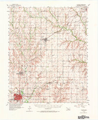
1957 Map of Clinton
USGS Topo · Published 1958About this map
Clinton and its surrounding Custer County landscape emerge as a vital transportation and agricultural hub in this late 1950s survey. The Washita River snakes through the southern portion of the quadrangle, where the urban center of Clinton is anchored by its rail connections and the Clinton Airport. The map highlights the transition of rural education and social life, noting the Red Rock Sch (Abandoned) alongside active centers like the Bellview Community Hall and Custer City High Sch.
Find a feature on this map
40 named features on this map. Tap any name to fly to it.
Don’t see what you’re looking for? This feature index may not catch every label — zoom into the map to look around manually.
Map Details
Editions of this 1957 Clinton Map
2 editions found
Other maps of this area

1955 · Clinton
USGS Topo · 1:250,000

1956 · Cordell
USGS Topo · 1:62,500

1957 · Clinton
USGS Topo · 1:250,000

1957 · Butler
USGS Topo · 1:62,500

1957 · Dill City
USGS Topo · 1:62,500

1961 · Eakly
USGS Topo · 1:62,500

1962 · Putnam
USGS Topo · 1:62,500

1962 · Aledo
USGS Topo · 1:62,500

1964 · Oakwood
USGS Topo · 1:62,500

1964 · Weatherford
USGS Topo · 1:62,500