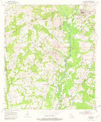
1954 Map of Clinton
USGS Topo · Published 1982About this map
Clinton serves as the focal point of this East Feliciana Parish landscape, where the Illinois Central line cuts across a territory defined by the winding course of the Comite River. The 1950s geography reveals a deeply established rural community, marked by an exceptionally high density of local landmarks including the Masonic Cem, Beutoville Cem, and Hawsey Cem. Education and faith are central to the settlement pattern, as evidenced by the distribution of the Ross and Dilly Sch, Spears Sch, and Beach Grove Ch No 2. Numerous bayous, such as Monahan Bayou and Knighton Bayou, create a complex drainage system that influenced the placement of early homesteads and cemeteries. This survey captures the parish before modern expansion, preserving the location of family-named features and small community hubs like Battle.
Find a feature on this map
44 named features on this map. Tap any name to fly to it.
Don’t see what you’re looking for? This feature index may not catch every label — zoom into the map to look around manually.
Map Details
Editions of this 1954 Clinton Map
4 editions found
Other maps of this area

1906 · Bayou Sara
USGS Topo · 1:125,000

1939 · Zachary
USGS Topo · 1:62,500

1941 · Woodland
USGS Topo · 1:31,680

1941 · Norwood
USGS Topo · 1:31,680

1941 · Lost Creek
USGS Topo · 1:31,680

1942 · Pride
USGS Topo · 1:31,680

1945 · Norwood
USGS Topo · 1:31,680

1945 · Jackson
USGS Topo · 1:31,680

1945 · Lost Creek
USGS Topo · 1:31,680

1946 · Clinton
USGS Topo · 1:31,680