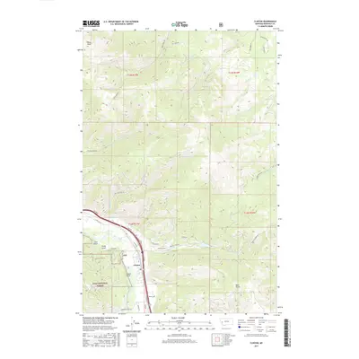
2017 Map of Clinton
USGS Topo · Published 2017About this map
The settlement of Clinton sits at the southern base of a steep, canyon-riven landscape where the Clark Fork river carves through the mountains. To the north, the terrain is defined by complex drainage networks including Bear Creek, Dirty Ike Cr, and Donovan Cr, which descend toward the valley floor from high points like Olson Peak. A significant portion of the southwestern quadrant is managed as part of the Lolo National Forest, characterized by deep topographic features such as Tule Gulch, Verdy Gulch, and Leeper Gulch. Transport through this corridor is anchored by Fas 210 and E Mullan Rd, following the river's natural path. The map details a transition from the structured residential roads of the valley, such as Pamin Loop and Clown Ln, to the winding forest routes like Dirty Ike Creek Rd and Bull Pine Rd that navigate the high-elevation backcountry.
Find a feature on this map
45 named features on this map. Tap any name to fly to it.
Don’t see what you’re looking for? This feature index may not catch every label — zoom into the map to look around manually.
Map Details
Editions of this 2017 Clinton Map
This is the sole edition of this map. No revisions or reprints were ever made.
Other maps of this area

1903 · Bonner
USGS Topo · 1:125,000

1947 · Butte
USGS Topo · 1:250,000

1958 · Butte
USGS Topo · 1:250,000

1959 · Cleveland Mountain
USGS Topo · 1:62,500

1959 · Ravenna
USGS Topo · 1:62,500

1960 · Butte
USGS Topo · 1:250,000

1962 · Butte
USGS Topo · 1:250,000
1965 · Sunflower Mountain
USGS Topo · 1:24,000
1965 · Clinton
USGS Topo · 1:24,000
1965 · Blue Point
USGS Topo · 1:24,000