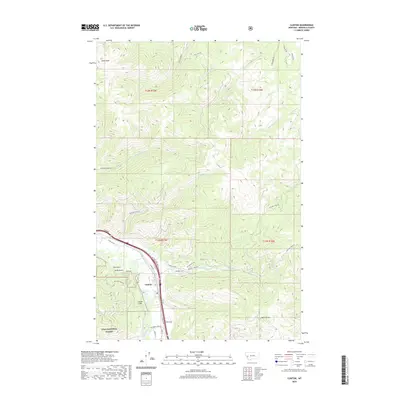
2020 Map of Clinton
USGS Topo · Published 2020About this map
The mountain settlement of Clinton occupies the narrow valley floor where the Clark Fork river meets a complex network of canyons and gulches. This modern survey illustrates the rugged interface between private land and the Lolo National Forest, where steep drainages like Tule Gulch and Leeper Gulch descend from heights such as Olson Peak. The presence of a Quarrie and numerous access routes including E Mullan Rd and Wallace Creek Rd highlights the area's continued reliance on resource extraction and its role as a corridor through the Bitterroot mountains. Upstream, the terrain is carved by dozens of seasonal and perennial streams like Dirty Ike Cr and Norman Cr, which feed the river system from high mountain ridges. Local navigation is defined by long-established landmarks like High Spr and the winding paths of Bridge Burn Trl and Ires Peak Rd.
Find a feature on this map
45 named features on this map. Tap any name to fly to it.
Don’t see what you’re looking for? This feature index may not catch every label — zoom into the map to look around manually.
Map Details
Editions of this 2020 Clinton Map
This is the sole edition of this map. No revisions or reprints were ever made.
Other maps of this area

1903 · Bonner
USGS Topo · 1:125,000

1947 · Butte
USGS Topo · 1:250,000

1958 · Butte
USGS Topo · 1:250,000

1959 · Cleveland Mountain
USGS Topo · 1:62,500

1959 · Ravenna
USGS Topo · 1:62,500

1960 · Butte
USGS Topo · 1:250,000

1962 · Butte
USGS Topo · 1:250,000
1965 · Sunflower Mountain
USGS Topo · 1:24,000
1965 · Clinton
USGS Topo · 1:24,000
1965 · Blue Point
USGS Topo · 1:24,000