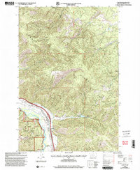
1999 Map of Clinton
USGS Topo · Published 2003About this map
Clark Fork defines the southern corridor of this landscape, where the settlement of Clinton sits at the junction of mountain drainages and river-level infrastructure. The map reveals a transition from the valley floor to the high elevations of the Garnet Range, with Olson Peak anchoring the northwest. Human activity here is marked by water management and mineral extraction, evidenced by the Clinton Irrigation District Canal tracing the river's edge and several mining operations tucked into the hills. Notable lode claims such as the Triangle Mine, Hidden Treasure Mine, and Bellview Mine are situated in the eastern slopes above Wallace Creek. This 1990s revision integrates forest management through the Lolo National Forest boundary with local recreation at the Swartz Creek Fishing Access. The land is further structured by the Standard Parallel North, which divides the terrain between sections of industrial prospecting and rugged wilderness.
Find a feature on this map
28 named features on this map. Tap any name to fly to it.
Don’t see what you’re looking for? This feature index may not catch every label — zoom into the map to look around manually.
Map Details
Editions of this 1999 Clinton Map
This is the sole edition of this map. No revisions or reprints were ever made.
Other maps of this area

1903 · Bonner
USGS Topo · 1:125,000

1947 · Butte
USGS Topo · 1:250,000

1958 · Butte
USGS Topo · 1:250,000

1959 · Cleveland Mountain
USGS Topo · 1:62,500

1959 · Ravenna
USGS Topo · 1:62,500

1960 · Butte
USGS Topo · 1:250,000

1962 · Butte
USGS Topo · 1:250,000
1965 · Sunflower Mountain
USGS Topo · 1:24,000
1965 · Clinton
USGS Topo · 1:24,000
1965 · Blue Point
USGS Topo · 1:24,000