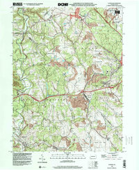
1998 Map of Clinton
USGS Topo · Published 2000About this map
Clinton and the northern reaches of Findlay and Robinson townships define this Western Pennsylvania landscape at the close of the 20th century. The northeastern corner is dominated by the sprawling infrastructure of the Greater Pittsburgh International Airport, signaling the modern era's expansion over the rural countryside. This industrial footprint contrasts sharply with the extensive Reclaimed Strip Mines and active Strip Mines that scar the hillsides, reflecting a long history of coal extraction.
Find a feature on this map
42 named features on this map. Tap any name to fly to it.
Don’t see what you’re looking for? This feature index may not catch every label — zoom into the map to look around manually.
Map Details
Editions of this 1998 Clinton Map
This is the sole edition of this map. No revisions or reprints were ever made.
Other maps of this area

1901 · Beaver
USGS Topo · 1:62,500

1904 · Beaver
USGS Topo · 1:62,500

1904 · Carnegie
USGS Topo · 1:62,500

1904 · Burgettstown
USGS Topo · 1:62,500

1906 · Burgettstown
USGS Topo · 1:62,500

1906 · Carnegie
USGS Topo · 1:62,500

1906 · Sewickley
USGS Topo · 1:62,500

1908 · Sewickley
USGS Topo · 1:62,500

1908 · Carnegie
USGS Topo · 1:62,500

1951 · Canton
USGS Topo · 1:250,000
Featured Places
- Independence Township, PA
- Robinson Township, PA
- Clinton, Findlay Township
- Hanover Township, PA
- Smith Township, PA