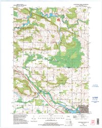
1993 Map of Clintonville North
USGS Topo · Published 1995About this map
The Embarrass River system defines the geography of this portion of northern Wisconsin, where the North Branch Embarrass River and South Branch Embarrass River converge near the rural settlement of Pella. The landscape is a mix of agricultural plots and low-lying wetlands, marked by features such as Pella Pond and the extensive Swamp Road. To the south, the city of Clintonville sits along the shores of Pigeon Lake, providing a clear view of the area's urban development at the close of the 20th century.
Find a feature on this map
33 named features on this map. Tap any name to fly to it.
Don’t see what you’re looking for? This feature index may not catch every label — zoom into the map to look around manually.
Map Details
Editions of this 1993 Clintonville North Map
This is the sole edition of this map. No revisions or reprints were ever made.
Other maps of this area

1954 · Gresham
USGS Topo · 1:48,000

1954 · Shawano
USGS Topo · 1:48,000

1955 · Embarrass
USGS Topo · 1:48,000

1955 · Clintonville
USGS Topo · 1:48,000

1955 · Green Bay
USGS Topo · 1:250,000

1964 · Shawano
USGS Topo · 1:62,500

1964 · Gresham
USGS Topo · 1:62,500

1969 · Embarrass
USGS Topo · 1:24,000

1969 · Bear Creek
USGS Topo · 1:24,000

1970 · Clintonville North
USGS Topo · 1:24,000