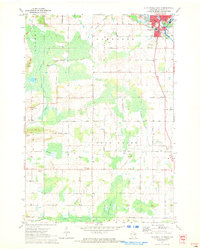
1970 Map of Clintonville South
USGS Topo · Published 1973About this map
Clintonville occupies the northeastern corner of this survey, where the Chicago And North Western railroad tracks cross near Pigeon Lake. The landscape is defined by its complex hydrology, dominated by the sprawling Dupont Swamp in the west and Blueberry Marsh in the south. These wetland systems are drained by a network of waterways including Bear Creek, Beaver Creek, and Brandy Creek, which dictated the early road patterns and settlement boundaries between the townships of Larrabee, Bear Creek, and Union.
Find a feature on this map
60 named features on this map. Tap any name to fly to it.
Don’t see what you’re looking for? This feature index may not catch every label — zoom into the map to look around manually.
Map Details
Editions of this 1970 Clintonville South Map
This is the sole edition of this map. No revisions or reprints were ever made.
Other maps of this area

1955 · Embarrass
USGS Topo · 1:48,000

1955 · Clintonville
USGS Topo · 1:48,000

1955 · Green Bay
USGS Topo · 1:250,000

1956 · New London
USGS Topo · 1:48,000

1956 · Weyauwega
USGS Topo · 1:48,000

1969 · New London
USGS Topo · 1:24,000

1969 · Northport
USGS Topo · 1:24,000

1969 · Embarrass
USGS Topo · 1:24,000

1969 · Bear Creek
USGS Topo · 1:24,000
1969 · Manawa
USGS Topo · 1:24,000