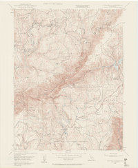
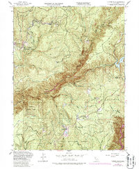
1948 Map of Clipper Mills
USGS Topo · Published 1959About this map
Plumas National Forest dominates this mid-century landscape where Butte and Yuba counties meet. The settlement of Clipper Mills and the nearby Clipper Mills School serve as local hubs for the timber and mining activities that once defined this ridge-and-canyon country. High-elevation points like Lumpkin Ridge and Fields Ridge overlook the deep drainage of the South Fork Feather River, which is fed by numerous named creeks and a network of canals and ditches.
Find a feature on this map
50 named features on this map. Tap any name to fly to it.
Don’t see what you’re looking for? This feature index may not catch every label — zoom into the map to look around manually.
Map Details
Editions of this 1948 Clipper Mills Map
5 editions found
Other maps of this area

1888 · Smartsville
USGS Topo · 1:125,000

1888 · Bidwell Bar
USGS Topo · 1:125,000

1891 · Bidwell Bar
USGS Topo · 1:125,000

1891 · Smartsville
USGS Topo · 1:125,000

1892 · Smartsville
USGS Topo · 1:125,000

1893 · Bidwell Bar
USGS Topo · 1:125,000

1894 · Smartsville
USGS Topo · 1:125,000

1895 · Bidwell Bar
USGS Topo · 1:125,000

1895 · Smartsville
USGS Topo · 1:125,000

1897 · Bidwell Bar
USGS Topo · 1:125,000