
1963 Map of Closter SE
USGS Topo · Published 1964About this map
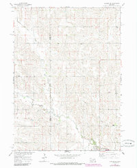
Newman Grove anchors the southern edge of this 1963 survey, where the rolling agricultural landscape of eastern Nebraska is defined by the winding course of Shell Creek and its various tributaries. The map documents a dense network of early rural social infrastructure, including nearly a dozen numbered schoolhouses such as School No 54 and School No 61, which speak to the area's history of independent rural school districts. The terrain is divided into regional sections named North Branch, Emerick, and Midland, reflecting early township or precinct identities. For genealogists, the map locates several critical community landmarks, including the Rose Hill Ch in the north and the Shell Creek Cem near the southern border. The landscape is primarily a drainage basin for North Branch Shell Creek and Dry Creek, showing the intricate field patterns and section lines that characterize the Missouri River Basin development era.
Find a feature on this map
21 named features on this map. Tap any name to fly to it.
Don’t see what you’re looking for? This feature index may not catch every label — zoom into the map to look around manually.
Map Details
Editions of this 1963 Closter SE Map
2 editions found
Other maps of this area

1955 · Fremont
USGS Topo · 1:250,000

1957 · Fremont
USGS Topo · 1:250,000

1958 · Fremont
USGS Topo · 1:250,000

1958 · Albion East
USGS Topo · 1:24,000

1963 · Closter SW
USGS Topo · 1:24,000

1963 · Emerick
USGS Topo · 1:24,000
1963 · Closter
USGS Topo · 1:24,000
1963 · Closter NE
USGS Topo · 1:24,000

1963 · Battle Creek SW
USGS Topo · 1:24,000
1966 · Newman Grove
USGS Topo · 1:24,000