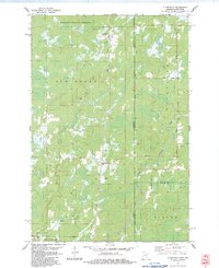
1983 Map of Cloverton
USGS Topo · Published 1983About this map
Cloverton and Kingsdale anchor this 1980s landscape along the border of Minnesota and Wisconsin, where the Soo Line railroad cuts a straight north-south path through the timber and wetlands. The region is defined by extensive public lands, including the Nemadji State Forest to the north and St Croix State Forest in the south, separated by the townships of New Dosey and Blaine. Drainage across this low-lying terrain is managed by a network of waterways such as the Spruce River and Tamarack River, which flow through areas marked by local transport routes like the Swedish Highway. The presence of several Gravel Pits and a remote Landing Strip suggests a landscape tied to resource extraction and forest management, while small settlements like Bjorks reflect the scattered nature of rural habitation in Pine County during this era.
Find a feature on this map
29 named features on this map. Tap any name to fly to it.
Don’t see what you’re looking for? This feature index may not catch every label — zoom into the map to look around manually.
Map Details
Editions of this 1983 Cloverton Map
This is the sole edition of this map. No revisions or reprints were ever made.
Other maps of this area

1949 · Danbury
USGS Topo · 1:48,000

1949 · Holyoke
USGS Topo · 1:48,000

1949 · Webb Lake
USGS Topo · 1:48,000

1949 · Patzau
USGS Topo · 1:48,000

1953 · Duluth
USGS Topo · 1:250,000

1955 · Webb Lake
USGS Topo · 1:62,500

1955 · Patzau
USGS Topo · 1:62,500

1958 · Duluth
USGS Topo · 1:250,000

1962 · Holyoke
USGS Topo · 1:62,500

1962 · Danbury
USGS Topo · 1:62,500