
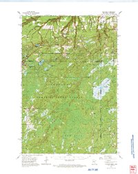
1962 Map of Holyoke
USGS Topo · Published 1964About this map
The Nemadji State Forest dominates this borderland landscape where the high, wooded plateaus of eastern Minnesota meet the Wisconsin state line. The survey captures the quiet rural character of the early 1960s, centered on the unincorporated settlement of Holyoke and the remote rail siding at Harlis. The northern portion of the quadrangle is defined by the headwaters of the Nemadji River and its numerous tributaries, including Clear Brook and Anderson Brook, which cut through the timbered terrain. Further south, the map reveals a vast wetland environment punctuated by dozens of small, isolated bodies of water like Net Lake, Pickerel Lake, and Delong Lake. This period of the mid-20th century shows the area's transition away from its early timber and rail roots, as the Great Northern Grade and local Gravel Pits remain as physical markers of the region's industrial past.
Find a feature on this map
41 named features on this map. Tap any name to fly to it.
Don’t see what you’re looking for? This feature index may not catch every label — zoom into the map to look around manually.
Map Details
Editions of this 1962 Holyoke Map
2 editions found
Other maps of this area

1915 · Superior
USGS Topo · 1:48,000

1917 · Superior
USGS Topo · 1:62,500

1949 · Danbury
USGS Topo · 1:48,000

1949 · Holyoke
USGS Topo · 1:48,000

1949 · Webb Lake
USGS Topo · 1:48,000

1949 · Patzau
USGS Topo · 1:48,000

1953 · Duluth
USGS Topo · 1:250,000

1954 · Borea
USGS Topo · 1:24,000

1954 · Foxboro
USGS Topo · 1:24,000

1954 · Wrenshall
USGS Topo · 1:24,000