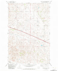
1982 Map of Cluster Buttes SW
USGS Topo · Published 1983About this map
Krug Creek and Griffith Creek define the drainage patterns of this Dawson County landscape during the early 1980s. The map illustrates a region transitioning between agricultural use and infrastructure development, dominated by the path of Interstate 94 and the Burlington Northern railroad in the southern section. Evidence of resource exploration is scattered throughout the township lines, indicated by several Well and Drill Hole sites located on the higher elevations.
Find a feature on this map
11 named features on this map. Tap any name to fly to it.
Don’t see what you’re looking for? This feature index may not catch every label — zoom into the map to look around manually.
Map Details
Editions of this 1982 Cluster Buttes SW Map
This is the sole edition of this map. No revisions or reprints were ever made.
Other maps of this area

1909 · Glendive
USGS Topo · 1:250,000

1953 · Miles City
USGS Topo · 1:250,000

1954 · Glendive
USGS Topo · 1:250,000

1957 · Miles City
USGS Topo · 1:250,000

1957 · Glendive
USGS Topo · 1:250,000

1958 · Miles City
USGS Topo · 1:250,000

1958 · Glendive
USGS Topo · 1:250,000

1967 · Allard
USGS Topo · 1:24,000

1967 · Belle Prairie
USGS Topo · 1:24,000

1967 · Twin Forks Reservoir
USGS Topo · 1:24,000