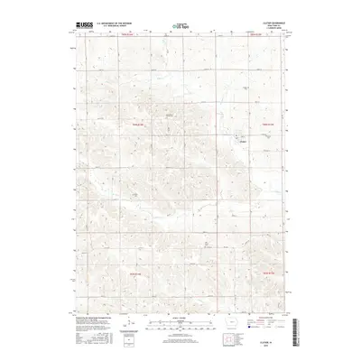
2015 Map of Clutier
USGS Topo · Published 2015About this map
Clutier serves as the primary hub of this eastern Iowa landscape, where the grid of sections is dictated by the deeply etched drainage of Wolf Cr and Salt Cr. The settlement patterns here remain tied to the section-line road network, reflecting a century of agricultural continuity in Tama County. Genealogy researchers will find significant value in the distribution of community burial grounds, including the Saint Vaclav Catholic Cem, which points to the specific ethnic heritage of the early settlers. The map records several other notable sites such as Oneida Cem, Wiese Cem, and Holy Trinity Cem, often located near prominent watercourses like S Br Salt Cr or Kibbe Cr. This detailed survey preserves the precise locations of rural infrastructure, from the winding paths of Co Rd V18 to the small-town streets of Clutier, against the backdrop of the region's fertile creek valleys.
Find a feature on this map
45 named features on this map. Tap any name to fly to it.
Don’t see what you’re looking for? This feature index may not catch every label — zoom into the map to look around manually.
Map Details
Editions of this 2015 Clutier Map
This is the sole edition of this map. No revisions or reprints were ever made.
Other maps of this area

1954 · Waterloo
USGS Topo · 1:250,000

1954 · Des Moines
USGS Topo · 1:250,000

1955 · Waterloo
USGS Topo · 1:250,000

1956 · Des Moines
USGS Topo · 1:250,000

1957 · Des Moines
USGS Topo · 1:250,000

1968 · Belle Plaine
USGS Topo · 1:24,000

1968 · Chelsea
USGS Topo · 1:24,000

1969 · Des Moines
USGS Topo · 1:250,000

1971 · Gladbrook NE
USGS Topo · 1:24,000
1971 · Elberon
USGS Topo · 1:24,000