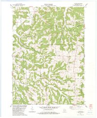
1983 Map of Clyde
USGS Topo · Published 1983About this map
Clyde sits at the northern edge of this landscape where the undulating terrain of Dunbar Hill and Union Ridge defines the drainage patterns of the Otter Creek watershed. The rural character of the early 1980s is evident in the network of ridges and deep valleys, such as Spring Valley and Norwegian Hollow, which dictated the placement of early homesteads and transport routes like Rohowetz Road and Goldmine Road.
Find a feature on this map
38 named features on this map. Tap any name to fly to it.
Don’t see what you’re looking for? This feature index may not catch every label — zoom into the map to look around manually.
Map Details
Editions of this 1983 Clyde Map
This is the sole edition of this map. No revisions or reprints were ever made.
Other maps of this area

1902 · Mineral Point
USGS Topo · 1:125,000

1905 · Richland Center
USGS Topo · 1:125,000

1952 · Dodgeville
USGS Topo · 1:24,000

1952 · Linden
USGS Topo · 1:24,000

1958 · La Crosse
USGS Topo · 1:250,000

1959 · Dubuque
USGS Topo · 1:250,000

1960 · Muscoda
USGS Topo · 1:62,500

1960 · Spring Green
USGS Topo · 1:62,500

1961 · Dubuque
USGS Topo · 1:250,000

1961 · La Crosse
USGS Topo · 1:250,000