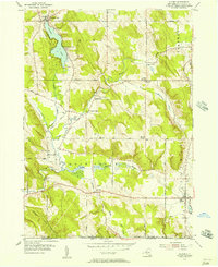
1954 Map of Clymer
USGS Topo · Published 1957About this map
Findley Lake serves as a primary focal point in the northwestern corner of this Chautauqua County landscape, where the settlement of the same name and Camp Findley sit along the shoreline. The terrain is characterized by the winding path of French Creek and its various tributaries, such as Beaver Meadow Brook and Pork Brook, which carve through the elevations of Mina, Sherman, and Clymer. The 1950s rural infrastructure is well-defined by an extensive network of family-named roads, including Cabbage Road, Bakerink Road, and Vruwink Road. Small hamlets like Cutting and Marks Corners anchor the crossroads, while numerous historical markers such as Taft Cem, Holland Cem, and the Edwards Chapel provide vital points of interest for local history and genealogical research. The presence of a Radio Tower (KBV 567) near Ravlin Hill highlights mid-century technological development amidst the traditional dairy and agricultural landscape of western New York.
Find a feature on this map
45 named features on this map. Tap any name to fly to it.
Don’t see what you’re looking for? This feature index may not catch every label — zoom into the map to look around manually.
Map Details
Editions of this 1954 Clymer Map
Other maps of this area

1905 · Clymer
USGS Topo · 1:62,500

1913 · North East
USGS Topo · 1:62,500

1915 · North East
USGS Topo · 1:62,500

1929 · Corry
USGS Topo · 1:48,000

1929 · Union City
USGS Topo · 1:62,500

1932 · Corry
USGS Topo · 1:62,500

1932 · Union City
USGS Topo · 1:62,500

1939 · Clymer
USGS Topo · 1:62,500

1941 · Clymer
USGS Topo · 1:62,500

1943 · North East
USGS Topo · 1:62,500