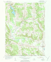
1954 Map of Clymer
USGS Topo · Published 1984About this map
Findley Lake serves as the focal point for this rural New York landscape, where the town of the same name and Camp Findley hug the northern shoreline. The terrain transitions from the lake basin into the meandering valley of French Creek, which cuts through the township alongside small hamlets like Marks Corners and Morgan Corners. This mid-century survey reveals a highly distributed settlement pattern, where narrow roads like Dutch Road and Vruwink Road connect family farms to local centers of worship and remembrance. Genealogy researchers will find several well-defined burial sites, including Taft Cem and Holland Cem, alongside landmarks such as Edwards Chapel and the St Matthias Ch with its adjacent St Matthias Cem. The southern reach of the map follows the winding Hare Creek toward the New York Pennsylvania state line, illustrating the remote agricultural character of Clymer and French Creek townships during the 1950s.
Find a feature on this map
50 named features on this map. Tap any name to fly to it.
Don’t see what you’re looking for? This feature index may not catch every label — zoom into the map to look around manually.
Map Details
Editions of this 1954 Clymer Map
Other maps of this area

1905 · Clymer
USGS Topo · 1:62,500

1913 · North East
USGS Topo · 1:62,500

1915 · North East
USGS Topo · 1:62,500

1929 · Corry
USGS Topo · 1:48,000

1929 · Union City
USGS Topo · 1:62,500

1932 · Corry
USGS Topo · 1:62,500

1932 · Union City
USGS Topo · 1:62,500

1939 · Clymer
USGS Topo · 1:62,500

1941 · Clymer
USGS Topo · 1:62,500

1943 · North East
USGS Topo · 1:62,500