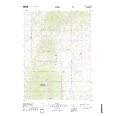
2017 Map of Coad Mountain
USGS Topo · Published 2017About this map
Medicine Bow National Forest dominates the southern half of this landscape, where the elevations of the Medicine Bow Mountains rise toward landmarks like Coad Mtn and Pennock Mtn. The terrain is defined by a series of distinct drainage basins and high-altitude passes, including Pass Creek Basin and Oberg Pass. A complex network of watercourses, such as Pass Cr, Jack Cr, and Brush Cr, flows through the canyons and gulches, reflecting the intricate hydrology of the Wyoming high country. Evidence of historical land management and water use appears in features like the Little Brush Cr Ditch and the winding route of Pass Creek Rd, which provides access through Pass Creek Canyon. The map reveals a remote environment where the natural topography of Indian Hill and Paulson Hill dictates the sparse path of human infrastructure in Carbon County.
Find a feature on this map
42 named features on this map. Tap any name to fly to it.
Don’t see what you’re looking for? This feature index may not catch every label — zoom into the map to look around manually.
Map Details
Editions of this 2017 Coad Mountain Map
This is the sole edition of this map. No revisions or reprints were ever made.
Other maps of this area

1893 · Fort Steele
USGS Topo · 1:125,000

1906 · Medicine Bow
USGS Topo · 1:125,000

1908 · Medicine Bow
USGS Topo · 1:125,000

1939 · Saratoga
USGS Topo · 1:125,000

1954 · Rawlins
USGS Topo · 1:250,000

1955 · Coal Bank Basin
USGS Topo · 1:24,000

1955 · Elk Mountain
USGS Topo · 1:24,000

1955 · Elk Mountain SW
USGS Topo · 1:24,000

1955 · Oberg Ranch
USGS Topo · 1:24,000

1955 · Rattlesnake Pass
USGS Topo · 1:24,000