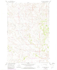
1960 Map of Coal Bank Creek
USGS Topo · Published 1980About this map
East Buffalo Creek and Coal Bank Creek carve through the landscape of Yellowstone County, Montana, in this mid-century topographic record. Part of a larger program for the development of the Missouri River Basin, the topography reflects a drainage-driven geography defined by coulees and creek beds that feed into larger water systems. To the south, Sevenmile Flat provides a break in the terrain near Sevenmile Creek, while the presence of Laylan Coulee and Carson Coulee indicates a highly dissected prairie environment. Photogrammetric methods from 1956 and revisions in 1978 highlight the area's rural character, showing the distribution of unimproved dirt roads and light-duty paths that connected isolated land parcels across Range 32 and 33 East. Significant named drainages like Antelope Creek serve as primary landmarks in a region dominated by agricultural use and natural water runoff patterns.
Find a feature on this map
8 named features on this map. Tap any name to fly to it.
Don’t see what you’re looking for? This feature index may not catch every label — zoom into the map to look around manually.
Map Details
Editions of this 1960 Coal Bank Creek Map
2 editions found
Other maps of this area

1954 · Forsyth
USGS Topo · 1:250,000

1957 · Forsyth
USGS Topo · 1:250,000

1958 · Forsyth
USGS Topo · 1:250,000

1960 · Coal Bank Creek
USGS Topo · 1:24,000

1960 · Custer
USGS Topo · 1:24,000

1960 · Waco
USGS Topo · 1:24,000
1960 · Mission Creek
USGS Topo · 1:24,000
1967 · Bull Mountain
USGS Topo · 1:24,000

1979 · Hysham
USGS Topo · 1:100,000
1979 · Devils Kitchen
USGS Topo · 1:24,000