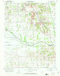
1963 Map of Coal City
USGS Topo · Published 1964About this map
Coal City and its surrounding coalfields define this 1963 landscape, where the New York Central railroad serves a terrain marked by numerous Strip Mines and a prominent Tipple at Daggett. The industrial character of the region contrasts with the quiet flow of the Eel River and the historical trace of the Wabash and Erie Canal (Abandoned), which cuts through the southern sections of Lewis and Jefferson townships. Genealogists will find a wealth of local landmarks, including over a dozen burial grounds such as Winters Cem, Bush Cem, and Scaffold Prairie Cem. Rural life is anchored by country congregations like New Hope Ch and Providence Ch, while recreational features like Tapawinga Lake and Muir Lake provide a different perspective on land use in this part of western Indiana.
Find a feature on this map
48 named features on this map. Tap any name to fly to it.
Don’t see what you’re looking for? This feature index may not catch every label — zoom into the map to look around manually.
Map Details
Editions of this 1963 Coal City Map
4 editions found
Other maps of this area

1908 · Clay City
USGS Topo · 1:48,000

1908 · Bloomfield
USGS Topo · 1:62,500

1910 · Clay City
USGS Topo · 1:62,500

1938 · Coal City
USGS Topo · 1:24,000

1938 · Switz City
USGS Topo · 1:24,000

1940 · Linton
USGS Topo · 1:24,000

1940 · Jasonville
USGS Topo · 1:24,000

1947 · Switz City
USGS Topo · 1:24,000

1947 · Linton
USGS Topo · 1:24,000

1948 · Coal City
USGS Topo · 1:24,000