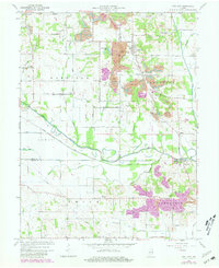
1963 Map of Coal City
USGS Topo · Published 1981About this map
Coal City sits at the center of a landscape heavily defined by its industrial and hydrological history, where the winding Eel River meets the remnants of the Wabash and Erie Canal. This survey reveals the intense land use of the mid-20th century, with numerous Strip Mine operations scattered throughout the townships of Harrison and Jefferson. The intersection of nature and industry is visible in features like Tapawingo Lake and the various feeder streams including Turkey Creek and Pond Creek.
Find a feature on this map
46 named features on this map. Tap any name to fly to it.
Don’t see what you’re looking for? This feature index may not catch every label — zoom into the map to look around manually.
Map Details
Editions of this 1963 Coal City Map
4 editions found
Other maps of this area

1908 · Clay City
USGS Topo · 1:48,000

1908 · Bloomfield
USGS Topo · 1:62,500

1910 · Clay City
USGS Topo · 1:62,500

1938 · Coal City
USGS Topo · 1:24,000

1938 · Switz City
USGS Topo · 1:24,000

1940 · Linton
USGS Topo · 1:24,000

1940 · Jasonville
USGS Topo · 1:24,000

1947 · Switz City
USGS Topo · 1:24,000

1947 · Linton
USGS Topo · 1:24,000

1948 · Coal City
USGS Topo · 1:24,000