
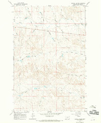
1967 Map of Coal Creek
USGS Topo · Published 1970About this map
Coal Creek and the branching drainages of the Big Dry Creek basin dominate this Garfield County landscape during the late 1960s. The terrain is a complex network of coulees and washes, including Calamity Coulee and Norwegian Coulee, which speak to the area's pioneer history and rugged hydrology. Evidence of land use is sparse but significant, with a Cem located near the northern border and a Gaging Sta monitoring water flow at the junction of Little Dry Creek and Big Little Horse Creek.
Find a feature on this map
23 named features on this map. Tap any name to fly to it.
Don’t see what you’re looking for? This feature index may not catch every label — zoom into the map to look around manually.
Map Details
Editions of this 1967 Coal Creek Map
This is the sole edition of this map. No revisions or reprints were ever made.
Other maps of this area

1954 · Jordan
USGS Topo · 1:250,000

1956 · Jordan
USGS Topo · 1:250,000

1958 · Jordan
USGS Topo · 1:250,000

1964 · Jordan
USGS Topo · 1:250,000

1965 · Whiteside Ranch
USGS Topo · 1:24,000

1965 · Hedstrom Lake NW
USGS Topo · 1:24,000

1965 · Hafla School
USGS Topo · 1:24,000

1967 · Hagen Gap
USGS Topo · 1:24,000
1967 · Maxwell Coulee
USGS Topo · 1:24,000

1967 · Frank Coulee
USGS Topo · 1:24,000