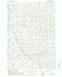
1984 Map of Coal Hill
USGS Topo · Published 1984About this map
The Cheyenne River and its western headwaters define this high-plains landscape in Converse County, where the transition from ranching terrain to industrial excavation is clearly visible. The southern portion of the map is dominated by a substantial Open Pit Mine located just north of the namesake Coal Hill, reflecting the intensive resource extraction that characterizes this region of Wyoming. The area's complex drainage network includes the Dry Fork, Phillips Creek, and Brown Springs Creek, all feeding into the larger river system. To the north, the Sage Creek Divide and the elevated terrain of Blizzard Heights provide a natural boundary for the watershed. Small-scale operations like Gravel Pits and prominent landmarks like Red Butte further punctuate a landscape shaped by both geological forces and modern industry.
Find a feature on this map
13 named features on this map. Tap any name to fly to it.
Don’t see what you’re looking for? This feature index may not catch every label — zoom into the map to look around manually.
Map Details
Editions of this 1984 Coal Hill Map
This is the sole edition of this map. No revisions or reprints were ever made.
Other maps of this area

1949 · Leuenberger Ranch
USGS Topo · 1:24,000

1949 · Glenrock NW
USGS Topo · 1:24,000

1949 · Hylton Ranch
USGS Topo · 1:24,000

1950 · Leuenberger Ranch
USGS Topo · 1:24,000

1950 · Glenrock NW
USGS Topo · 1:24,000
1950 · Hylton Ranch
USGS Topo · 1:24,000

1954 · Torrington
USGS Topo · 1:250,000

1955 · Newcastle
USGS Topo · 1:250,000

1958 · Torrington
USGS Topo · 1:250,000

1958 · Newcastle
USGS Topo · 1:250,000