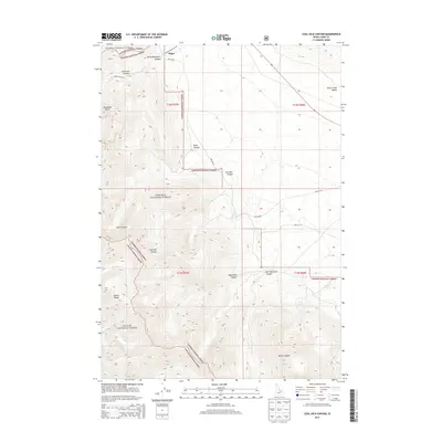
2013 Map of Coal Kiln Canyon
USGS Topo · Published 2013About this map
Hahn sits at the northern edge of this high-elevation landscape, where the Lemhi Range meets a complex network of timbered canyons and seasonal drainages. The area is defined by the convergence of the Salmon National Forest, Targhee National Forest, and Challis National Forest, indicating a significant forest management hub in Lemhi County. Water sources are critical features in this arid mountain terrain, with named points such as Coal Kiln Spring, Box Springs, and Willow Spring marking essential stops for range users and wildlife. The eastern portion of the map transitions into the Birch Creek Valley, while the western side is dominated by steep-walled features like Coal Kiln Canyon and Mammoth Canyon. Local access is maintained via forest routes like Spring Mountain Rd and NFD 188 Rd, providing a look at the backcountry infrastructure used for ranching and resource management.
Find a feature on this map
29 named features on this map. Tap any name to fly to it.
Don’t see what you’re looking for? This feature index may not catch every label — zoom into the map to look around manually.
Map Details
Editions of this 2013 Coal Kiln Canyon Map
This is the sole edition of this map. No revisions or reprints were ever made.
Other maps of this area

1955 · Dubois
USGS Topo · 1:250,000

1956 · Nicholia
USGS Topo · 1:62,500

1957 · Diamond Peak
USGS Topo · 1:62,500

1957 · Gilmore
USGS Topo · 1:62,500

1957 · Hawley Mountain
USGS Topo · 1:62,500

1958 · Dubois
USGS Topo · 1:250,000

1987 · Gilmore
USGS Topo · 1:24,000
1987 · Mulkey Bar
USGS Topo · 1:24,000
1987 · Gilmore Summit
USGS Topo · 1:24,000
1987 · Nicholia
USGS Topo · 1:24,000