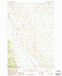
1987 Map of Gilmore Summit
USGS Topo · Published 1987About this map
Gilmore Summit serves as the topographic high point on this 1980s-era survey, marking the continental Divide between the Lemhi River and Birch Creek Valley. The landscape is defined by the sharp rise of Center Ridge and the deep cuts of Long Canyon and Bruce Canyon. The presence of an Old Railroad Grade and numerous prospects suggests a history of resource extraction and transit through these high-altitude passes. This area, shared between the Salmon National Forest and Targhee National Forest, is dotted with named water sources such as Allhands Spring, Slaughterhouse Spring, and Robertson Spring. Several primitive 4 WD roads and trails traverse the terrain, connecting the drainage basins of Texas Creek and Mc Ginty Creek across the Idaho-Lemhi county line.
Find a feature on this map
25 named features on this map. Tap any name to fly to it.
Don’t see what you’re looking for? This feature index may not catch every label — zoom into the map to look around manually.
Map Details
Editions of this 1987 Gilmore Summit Map
This is the sole edition of this map. No revisions or reprints were ever made.
Other maps of this area

1955 · Dubois
USGS Topo · 1:250,000

1956 · Leadore
USGS Topo · 1:62,500

1956 · Morrison Lake
USGS Topo · 1:62,500

1956 · Nicholia
USGS Topo · 1:62,500

1957 · Gilmore
USGS Topo · 1:62,500

1958 · Dubois
USGS Topo · 1:250,000

1980 · Leadore
USGS Topo · 1:100,000

1987 · Gilmore
USGS Topo · 1:24,000
1987 · Morrison Lake
USGS Topo · 1:24,000

1987 · Purcell Spring
USGS Topo · 1:24,000