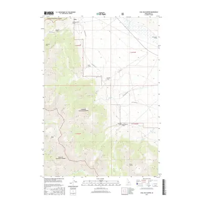
2017 Map of Coal Kiln Canyon
USGS Topo · Published 2017About this map
The Lemhi Range dominates this portion of Lemhi County, serving as a convergence point for three major protected landscapes: Salmon National Forest, Targhee National Forest, and Challis National Forest. The topography is defined by sharp elevation changes between the high peaks and the Birch Creek Valley to the east. Historically, the area shows evidence of early resource extraction and high-altitude activity, most notably at the settlement of Hahn and through the industrial naming of Coal Kiln Canyon.
Find a feature on this map
29 named features on this map. Tap any name to fly to it.
Don’t see what you’re looking for? This feature index may not catch every label — zoom into the map to look around manually.
Map Details
Editions of this 2017 Coal Kiln Canyon Map
This is the sole edition of this map. No revisions or reprints were ever made.
Other maps of this area

1955 · Dubois
USGS Topo · 1:250,000

1956 · Nicholia
USGS Topo · 1:62,500

1957 · Diamond Peak
USGS Topo · 1:62,500

1957 · Gilmore
USGS Topo · 1:62,500

1957 · Hawley Mountain
USGS Topo · 1:62,500

1958 · Dubois
USGS Topo · 1:250,000

1987 · Gilmore
USGS Topo · 1:24,000
1987 · Mulkey Bar
USGS Topo · 1:24,000
1987 · Gilmore Summit
USGS Topo · 1:24,000
1987 · Nicholia
USGS Topo · 1:24,000