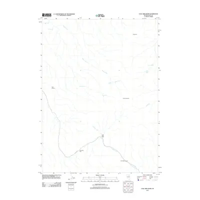
2012 Map of Coal Mine Basin
USGS Topo · Published 2012About this map
Coal Mine Basin serves as the central hub of this high-desert landscape in Elko County, where the topography is defined by its namesake resource and remote ranching access. The southern portion of the map is dominated by a trio of features including Coal Mine Canyon, Coal Mine Pass, and the primary thoroughfare, Coal Mine Rd. This network suggests an era where local transit was heavily influenced by the geography of the surrounding basins. Water sources are critical identifiers in this arid terrain, with numerous vital points such as Blackrock Spring, Cherry Spring, and Badger Spring scattered throughout. The northeastern corner is punctuated by isolated peaks like Sugarloaf and Tower Mountain, while hidden drainages such as Coal Canyon and Big Creek provide essential markers for land navigation and historical grazing routes.
Find a feature on this map
17 named features on this map. Tap any name to fly to it.
Don’t see what you’re looking for? This feature index may not catch every label — zoom into the map to look around manually.
Map Details
Editions of this 2012 Coal Mine Basin Map
This is the sole edition of this map. No revisions or reprints were ever made.
Other maps of this area

1955 · Wells
USGS Topo · 1:250,000

1958 · Wells
USGS Topo · 1:250,000

1961 · Wells
USGS Topo · 1:250,000
1971 · Coal Mine Basin
USGS Topo · 1:24,000
1971 · Dinner Station
USGS Topo · 1:24,000
1971 · The Buttes
USGS Topo · 1:24,000
1971 · Wieland Flat
USGS Topo · 1:24,000

1971 · Double Mtn SE
USGS Topo · 1:24,000
1971 · Coal Mine Canyon SE
USGS Topo · 1:24,000
1971 · Mahala Creek East
USGS Topo · 1:24,000