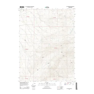
2014 Map of Coal Mine Basin
USGS Topo · Published 2014About this map
Coal Mine Basin and the adjacent Adobe Range define the high-altitude landscape of this northern Nevada survey. The area is marked by a network of seasonal water sources and canyons, with topographic highlights such as Tower Mtn and the distinct peak of Sugarloaf. The drainage pattern is complex, with Badger Cr and Coal Mine Cr carving through the terrain. Evidence of the region's ranching and mining potential is seen in the naming of features like Coal Mine Pass and the numerous vital water points including Blackrock Spring, Cherry Spring, and Five Springs. The map illustrates the varied land divisions of the Public Land Survey System, including sections of t38n r56e and t39n r55e, providing a clear view of the territorial organization in Elko County.
Find a feature on this map
26 named features on this map. Tap any name to fly to it.
Don’t see what you’re looking for? This feature index may not catch every label — zoom into the map to look around manually.
Map Details
Editions of this 2014 Coal Mine Basin Map
This is the sole edition of this map. No revisions or reprints were ever made.
Other maps of this area

1955 · Wells
USGS Topo · 1:250,000

1958 · Wells
USGS Topo · 1:250,000

1961 · Wells
USGS Topo · 1:250,000
1971 · Coal Mine Basin
USGS Topo · 1:24,000
1971 · Dinner Station
USGS Topo · 1:24,000
1971 · The Buttes
USGS Topo · 1:24,000
1971 · Wieland Flat
USGS Topo · 1:24,000

1971 · Double Mtn SE
USGS Topo · 1:24,000
1971 · Coal Mine Canyon SE
USGS Topo · 1:24,000
1971 · Mahala Creek East
USGS Topo · 1:24,000