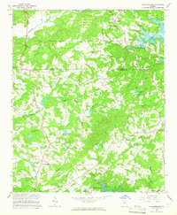
1964 Map of Coal Mountain
USGS Topo · Published 1965About this map
Lumpkin and Coal Mountain serve as primary anchors for this northern Forsyth County landscape, where the rising waters of Lake Sidney Lanier began to reshape the local geography in the mid-1960s. The map illustrates a transitional period for the region, documenting a network of rural roads such as Taylor Road and Burruss Road that connect isolated farmsteads and historic community centers. The northern reach is defined by the Etowah River and Black Mill Creek, while the eastern portion highlights the early development of recreation at the Thompson Creek Access Point. Cultural sites are well-preserved in this record, including Bethel Ch, Hopewell Ch, and Byrd Cem. The terrain is characterized by named elevations like Pea Ridge and Baldridge Ridge, which dictate the winding paths of the local road system through the Piedmont hills.
Find a feature on this map
55 named features on this map. Tap any name to fly to it.
Don’t see what you’re looking for? This feature index may not catch every label — zoom into the map to look around manually.
Map Details
Editions of this 1964 Coal Mountain Map
3 editions found
Other maps of this area

1890 · Suwanee
USGS Topo · 1:125,000

1891 · Gainesville
USGS Topo · 1:125,000

1894 · Suwanee
USGS Topo · 1:125,000

1954 · Greenville
USGS Topo · 1:250,000

1955 · Rome
USGS Topo · 1:250,000

1958 · Greenville
USGS Topo · 1:250,000

1958 · Rome
USGS Topo · 1:250,000

1961 · Rome
USGS Topo · 1:250,000

1963 · Rome
USGS Topo · 1:250,000

1964 · Murrayville
USGS Topo · 1:24,000