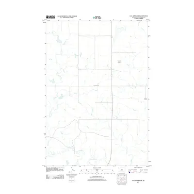
2012 Map of Coal Springs NW
USGS Topo · Published 2012About this map
Thunder Butte Cr meanders across this rural expanse of Perkins County, defining a landscape of wide drainages and intermittent watercourses. The territory is characterized by its agricultural utility and private aviation infrastructure, evidenced by the presence of the Lensegrav Ranch Airstrip in the north and the Nelson Airstrip to the east. These private runways highlight the vast distances and ranching economy typical of the western South Dakota plains. A simple road network, including the east-west Rolling Hills Rd, connects the isolated ranching operations. The drainage patterns of Big Meadow Cr and Duncan Cr illustrate the subtle topography and the natural flow of water toward the larger creek systems, which remain central to the region's geography.
Find a feature on this map
6 named features on this map. Tap any name to fly to it.
Don’t see what you’re looking for? This feature index may not catch every label — zoom into the map to look around manually.
Map Details
Editions of this 2012 Coal Springs NW Map
This is the sole edition of this map. No revisions or reprints were ever made.
Other maps of this area

1954 · Lemmon
USGS Topo · 1:250,000

1957 · Lemmon
USGS Topo · 1:250,000

1983 · Boxcar Buttes
USGS Topo · 1:24,000

1983 · Coal Springs
USGS Topo · 1:24,000

1983 · Sunrise Butte
USGS Topo · 1:24,000

1983 · Meadow
USGS Topo · 1:24,000

1983 · Coal Springs SW
USGS Topo · 1:24,000
1983 · Coal Springs SE
USGS Topo · 1:24,000
1983 · Meadow SE
USGS Topo · 1:24,000

1983 · Coal Springs NW
USGS Topo · 1:24,000