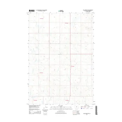
2015 Map of Coal Springs NW
USGS Topo · Published 2015About this map
Big Meadow Cr and its tributaries carve a subtle network of drainages across this portion of Perkins County, revealing a landscape defined by seasonal watercourses and the open range of South Dakota. The drainage systems of Thunder Butte Cr and Duncan Cr dominate the southern and eastern portions of the quadrangle, illustrating the natural flow patterns toward larger basins beyond the map boundaries. Human infrastructure is minimal, represented primarily by Rolling Hills Rd, which provides a horizontal corridor through the central hills. This survey documents the sprawling Public Land Survey System divisions, including Township t18n r15e and Township t17n r16e, showcasing how early land-office grids remain the primary organizational framework for this remote prairie terrain into the twenty-first century.
Find a feature on this map
10 named features on this map. Tap any name to fly to it.
Don’t see what you’re looking for? This feature index may not catch every label — zoom into the map to look around manually.
Map Details
Editions of this 2015 Coal Springs NW Map
This is the sole edition of this map. No revisions or reprints were ever made.
Other maps of this area

1954 · Lemmon
USGS Topo · 1:250,000

1957 · Lemmon
USGS Topo · 1:250,000

1983 · Boxcar Buttes
USGS Topo · 1:24,000

1983 · Coal Springs
USGS Topo · 1:24,000

1983 · Sunrise Butte
USGS Topo · 1:24,000

1983 · Meadow
USGS Topo · 1:24,000

1983 · Coal Springs SW
USGS Topo · 1:24,000
1983 · Coal Springs SE
USGS Topo · 1:24,000
1983 · Meadow SE
USGS Topo · 1:24,000

1983 · Coal Springs NW
USGS Topo · 1:24,000