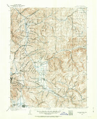
1900 Map of Coalville
USGS Topo · Published 1963About this map
Coalville and the Weber River valley serve as the primary corridor for settlement and industry at the turn of the century. This survey documents the critical mining and transportation infrastructure of the era, most notably the Ontario Drain Tunnel near Park City, a massive engineering feat vital to the regional silver mining operations. The landscape is defined by its canyon systems, such as Echo Canyon and Grass Valley Canyon, which channeled the routes of the Union Pacific R. R. and the Utah Central R. R.. These rail lines connected established mountain towns like Wanship and Hoytsville to the broader western economy. To the south, Rhodes Valley opens into a fertile agricultural region anchored by Kamas and Heber, while the high peaks are designated within the Wasatch National Forest and Uinta National Forest, reflecting the early days of federal land management.
Find a feature on this map
126 named features on this map. Tap any name to fly to it.
Don’t see what you’re looking for? This feature index may not catch every label — zoom into the map to look around manually.
Map Details
Editions of this 1900 Coalville Map
2 editions found
Other maps of this area

1885 · Salt Lake
USGS Topo · 1:250,000

1885 · Uinta
USGS Topo · 1:250,000

1900 · Coalville
USGS Topo · 1:125,000

1901 · Hayden Peak
USGS Topo · 1:125,000

1903 · Hayden Peak
USGS Topo · 1:125,000

1903 · Coalville
USGS Topo · 1:125,000

1907 · Strawberry Valley
USGS Topo · 1:125,000

1909 · Strawberry Valley
USGS Topo · 1:125,000

1925 · Ft. Douglas
USGS Topo · 1:125,000

1928 · Ft. Douglas
USGS Topo · 1:125,000