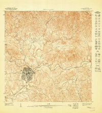
1947 Map of Coamo NO
USGS Topo · Published 1947About this map
Coamo serves as the central hub for this 1940s topographic study, showing a concentrated grid of streets and buildings at the base of the mountains. The terrain is defined by the sharp descent of the Rio Coamo and the Rio Cuyon, which carve through the high elevations near Cerro Santa Ana. Small agricultural settlements like San Diego and Cacao appear as clusters of structures connected by winding roads through the interior hills. The map highlights the boundary between the Municipio de Coamo and the Municipio de Aibonito to the northeast. This preliminary edition, based on 1943 topography, captures the traditional land use and infrastructure of the region before significant mid-century modernizations changed the character of the mountain towns.
Find a feature on this map
10 named features on this map. Tap any name to fly to it.
Don’t see what you’re looking for? This feature index may not catch every label — zoom into the map to look around manually.
Map Details
Editions of this 1947 Coamo NO Map
This is the sole edition of this map. No revisions or reprints were ever made.
Other maps of this area

1945 · Rio Descalabrado
USGS Topo · 1:30,000

1946 · Coamo
USGS Topo · 1:30,000

1946 · Barranquitas
USGS Topo · 1:30,000

1946 · Orocovis
USGS Topo · 1:30,000
1947 · Rio Descalabrado SE
USGS Topo · 1:10,000
1947 · Orocovis SE
USGS Topo · 1:10,000
1947 · Rio Descalabrado NE
USGS Topo · 1:10,000
1947 · Coamo SO
USGS Topo · 1:10,000
1947 · Barranquitas SE
USGS Topo · 1:10,000
1947 · Coamo NE
USGS Topo · 1:10,000