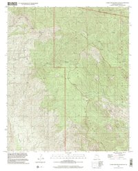
1998 Map of Cobre Grande Mountain
USGS Topo · Published 2002About this map
Cobre Grande Mountain anchors this rugged section of the Santa Teresa Mountains, where the landscape is defined by a series of high-desert springs and steep drainages. The map reveals a history of hard-rock mining at the southern end of the range, centered around the Grand Reef Mine, Princess Pat Mine, and Cobre Grande Mine. These operations were supported by isolated outposts such as Landsman Camp and the Roten Cabin Site, situated near the headwaters of seasonal gulches.
Find a feature on this map
50 named features on this map. Tap any name to fly to it.
Don’t see what you’re looking for? This feature index may not catch every label — zoom into the map to look around manually.
Map Details
Editions of this 1998 Cobre Grande Mountain Map
This is the sole edition of this map. No revisions or reprints were ever made.
Other maps of this area

1938 · Klondyke
USGS Topo · 1:48,000

1943 · Klondyke
USGS Topo · 1:62,500

1944 · Jackson Mtn.
USGS Topo · 1:62,500

1946 · Jackson Mtn.
USGS Topo · 1:62,500

1954 · Mesa
USGS Topo · 1:250,000

1956 · Tucson
USGS Topo · 1:250,000

1957 · Mesa
USGS Topo · 1:250,000

1958 · Mesa
USGS Topo · 1:250,000

1958 · Tucson
USGS Topo · 1:250,000

1959 · Tucson
USGS Topo · 1:250,000