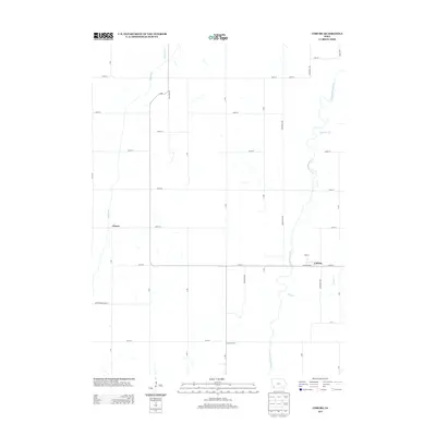
2013 Map of Coburg
USGS Topo · Published 2013About this map
The E Nishnabotna River meanders through this portion of Montgomery County, defining the agricultural landscape of southwestern Iowa. The small community of Coburg serves as a focal point near the eastern edge of the map, situated at the intersection of Iowa St and Pleasant Ave. To the west, the crossroads settlement of Climax marks the interior, surrounded by a highly organized grid of rural roads like A Ave and 260th St. This 2013 survey illustrates the persistence of small-town Iowa, where drainage patterns from Mormon Br, Ramp Cr, and Walnut Cr dictate the field lines. Further south, the label for Franklin Grove suggests a localized landmark within the vast expanse of cultivated land, while the southern boundary follows Montgomery-Page St along the county line.
Find a feature on this map
34 named features on this map. Tap any name to fly to it.
Don’t see what you’re looking for? This feature index may not catch every label — zoom into the map to look around manually.
Map Details
Editions of this 2013 Coburg Map
This is the sole edition of this map. No revisions or reprints were ever made.
Other maps of this area

1954 · Omaha
USGS Topo · 1:250,000

1955 · Nebraska City
USGS Topo · 1:250,000

1957 · Nebraska City
USGS Topo · 1:250,000

1957 · Omaha
USGS Topo · 1:250,000

1958 · Omaha
USGS Topo · 1:250,000

1958 · Nebraska City
USGS Topo · 1:250,000

1978 · Shenandoah East
USGS Topo · 1:24,000
1978 · Emerson
USGS Topo · 1:24,000

1978 · Stanton SW
USGS Topo · 1:24,000

1978 · Wales
USGS Topo · 1:24,000